
What happened
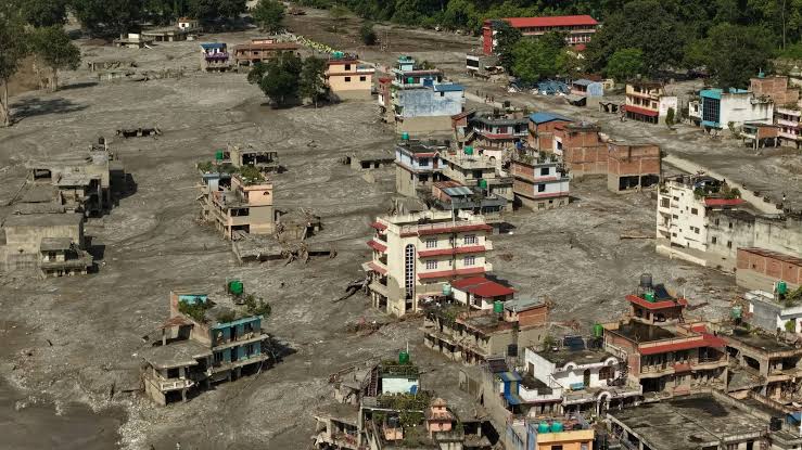
The August 26, 2026 Bhotekoshi Flash Flood was a high-altitude cryospheric disaster that occurred along the transboundary Bhotekoshi–Trishuli river system spanning Tibet (China) and Nepal. Triggered by a complex cascade of ice, rock, and debris failures high in the Himalayas rather than local surface rainfall, the event funneled down narrow alpine valleys, resulting in extensive destruction across several central districts in Nepal.
Initiating Mechanism
The event originated on the northern flanks of the Langtang Lirung and Tsangbu Ri mountain massif near the Nepal–China border.
- Glacial Collapse: A massive section of a hanging glacier and its underlying bedrock failed at high altitude, falling down a steep cliff face.
- Seismic Signature: The kinetic impact of the collapsing ice and rock mass was so immense that global monitoring networks initially misidentified the resulting signal as a natural tectonic earthquake. Long-period wave analysis later confirmed the signature was produced by a massive slope movement.
Chain Sequence & Progression
The collapse initiated a multi-stage disaster sequence across the high-altitude terrain:
- Valley Blockage: The tumbling avalanche of ice, rock, and soil plunged into the Lhende Khola valley (a major headwater tributary of the Bhotekoshi River). The fallen material created a temporary natural dam that impounded the river, causing water to rapidly pool into an unstable temporary debris lake.
- Dam Breach: After holding for several hours, the artificial structure failed under immense hydrostatic pressure, unleashing the impounded water in a sudden burst.
- Debris Flow Dynamics: As the outburst rushed into the steep, narrow gorge of the main Bhotekoshi river corridor, the terrain accelerated the flow velocity. The water entrained vast quantities of sediment, boulders, uprooted trees, and glacial material, morphing from clear water into a high-density, destructive slurry.
Impact & Target Areas
The mud-and-rock surge traveled downstream along the Bhotekoshi and Trishuli river corridors, impacting infrastructure and communities across Rasuwa, Nuwakot, Dhading, and Chitwan districts:
- Border Points & Bilateral Trade: The initial surge struck the Miteri Bridge and surrounding international customs facilities, washing away the border post at the Gyirong/Rasuwagadhi checkpoint and cutting off a primary ground trade route connecting Nepal and China.
- Energy Infrastructure: The river valley hosts a high concentration of energy assets; the heavy sediment and boulder load damaged and inundated several major run-of-the-river hydroelectric power plants and associated switchyards along the riverbanks.
- Transportation & Communication: The surge tore away critical mountain highways, suspension bridges, and motorable bridges built over the river bed, completely isolating multiple remote settlements. Telecommunication towers along the river plain were knocked offline, creating a blackout in real-time reporting.
- Settlements: Riparian villages, local markets, and residential areas situated on lower river terraces were inundated, covered in thick layers of silt, debris, and boulders.
Scientific Assessment
Disaster monitoring agencies and scientists noted that the event stood out because it occurred without heavy monsoon rainfall in the immediate area—a phenomenon known as a "clear-day flood". Researchers attribute the underlying vulnerability to warming high-altitude microclimates, which degrade permafrost and compromise the structural stability of hanging glaciers in the High Himalayas.
 1 / 4
1 / 4